Before You Choose a Launch Site
Norway makes spectacular aerial images look effortless. They are not. Mountains can break visual line of sight, wind changes quickly across ridges, popular viewpoints fill with uninvolved people, and a legal-looking take-off point can still sit inside restricted airspace or protected nature.
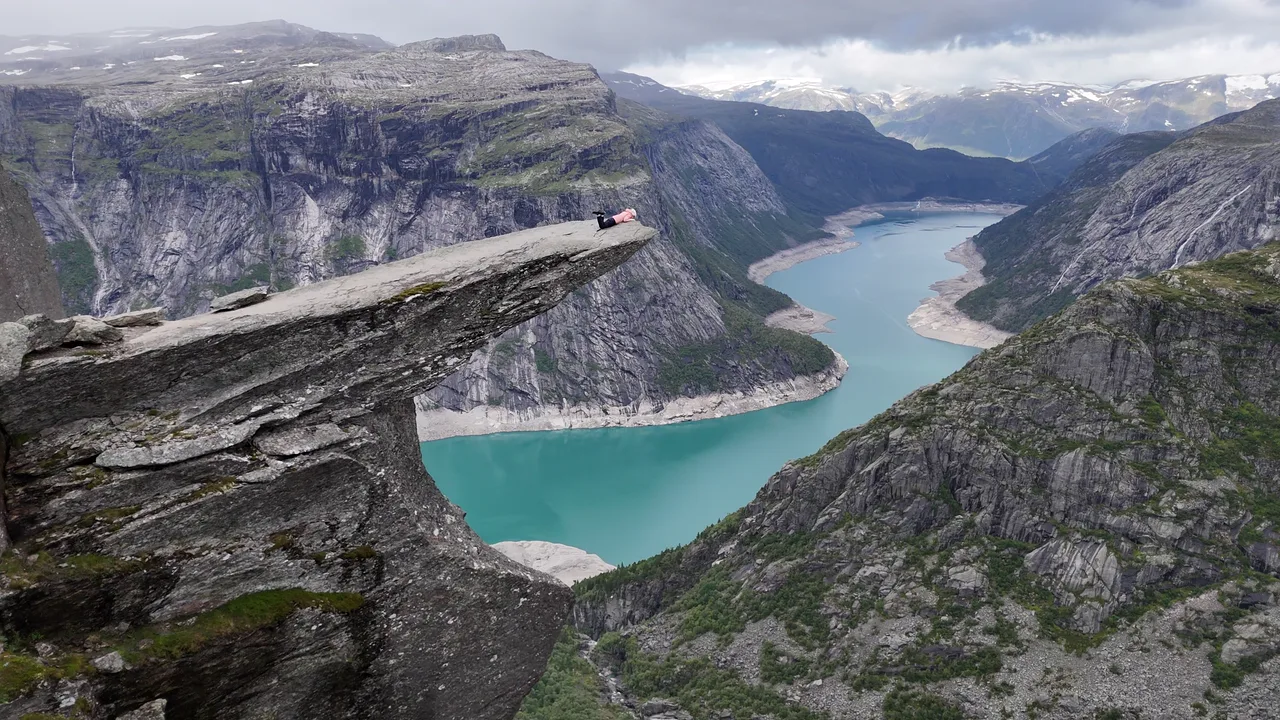
The two films in this guide show Trolltunga above Ringedalsvatnet and a hike identified by its creator as Litltinden. They are visual references, not proof that the same flight is permitted today. Use the workflow below for your exact coordinates, date, aircraft and route.
Looking for Norway's best-known cliff instead? The site manager gives a direct no: read why drones are prohibited at Preikestolen and what to photograph instead.
Norway Rules That Shape the Shot
Most visiting recreational and commercial pilots operate in the EASA Open category. In Norway that normally means keeping the aircraft in visual line of sight, remaining within 120 metres of the closest point of the earth, never flying over an assembly of people and following the A1, A2 or A3 limits that match the aircraft.
Operator registration, competency and insurance depend on the aircraft and operator. Visitors registered in another EASA member state normally use that registration in Norway; pilots arriving from outside the EASA system generally register in the first EASA country where they will operate. Camera and sensor use must also be registered with the Norwegian National Security Authority where required. Start with our checked Norway drone-law guide, then confirm the live position with the Norwegian authorities.
Norway's airport tool is only one layer. Avinor states that permission is required within five kilometres of an airport and that NinoxDrone2 can handle requests at supported airports. Avinor also warns that NinoxDrone2 is not a complete map of prohibition and restriction areas. Check the official UAS geographical-zone map, NOTAM, protected nature and sensor restrictions separately.
Trolltunga: Iconic, Busy and Usually a Poor Drone Plan
Trolltunga is a dramatic subject, but the famous ledge is also a concentrated safety problem. The official destination website strongly advises against drone use and says never to fly when other people are on Trolltunga. Its photo-queue guidance also asks pilots to avoid drone flight when many people are present. A sub-250-gram drone does not cancel that advice or the rule against flying over assemblies.
The hike itself is a serious part of the flight plan. From P2 Skjeggedal, the official route is about 27 kilometres return and typically takes 8–12 hours. Weather and visibility can change during that window, while batteries cool and the number of visitors changes. A plan made in the car park is not automatically valid at the ledge.
Use this decision rule
- If anyone is on the exposed rock or your route could pass above people, do not launch.
- If the viewpoint is busy, use a ground camera and let the aerial shot go.
- If cloud, ridge geometry or distance would interrupt direct visual line of sight, shorten or cancel the route.
- If any live map, NOTAM, nature rule or site instruction conflicts with the plan, the flight does not proceed.
A safer creative alternative is a ground panorama from the plateau, or a licensed aerial clip obtained with documented permission and conditions. The film above is inspiration, not a recommended route.
Litltind Near Bodø: A Quieter Mountain Subject
The landscape in the film is consistent with the Litltind hike north of Bodø, starting near Skarvvatnet on the road towards Kjerringøy. UT.no describes that route as a 7.1-kilometre return hike to 717 metres, with open coastal views. Because the Pexels listing does not supply coordinates, confirm that this is the exact mountain you intend to visit before using any route or aviation information.
Fewer people do not automatically mean unrestricted flight. Coastal mountains around Bodø can be affected by airport and controlled-airspace considerations, helicopter traffic, weather, wildlife and protected areas. Plot both the launch point and the complete intended flight path—not just the summit—in the official map. Check NOTAM on the day and keep a large margin for wind, cold and the return leg.
A shot plan that asks less of the aircraft
- Scout the ridge from the ground and choose one clear foreground-to-coast composition.
- Set a short flight box that remains visible from one pilot position.
- Use the terrain-following 120-metre limit from the closest surface, not height above take-off.
- Keep uninvolved hikers outside the operating area and stop if they enter it.
- Capture one establishing pass and one static reveal, then land with a conservative battery reserve.
Seven Checks Before Take-off
- Pilot and aircraft: confirm registration, operator marking, certificate, class/subcategory and liability insurance.
- Exact coordinates: verify the intended mountain, launch point, route and emergency landing area.
- UAS geographical zones: read every restriction in the official Norwegian drone map.
- Current air activity: check official NOTAM and give all crewed aircraft—especially rescue helicopters—immediate priority.
- Nature and sensors: check protected-area rules, seasonal wildlife restrictions and the National Security Authority's sensor map and registration requirements.
- Ground access and people: check land-manager instructions, parking and trail rules; reassess visitor numbers at launch time.
- Conditions: set firm limits for wind, visibility, cloud, temperature and battery before walking in.
Save screenshots or links for the checks you rely on, but refresh time-sensitive information immediately before flight. Manufacturer flight apps are useful technical aids; they are not the legal source for Norwegian airspace.
What These Videos Do—and Do Not—Show
The films show why both landscapes are attractive: strong foregrounds, deep water, layered ridges and scale. They do not reveal the operator's authorisations, the exact date, temporary restrictions, people outside the frame, protected-area conditions or the full route flown. That missing context is why responsible location guides should explain decisions rather than publish a bare list of coordinates.
For planning elsewhere in the country, combine the same method with the official drone-map directory. If any source disagrees, follow the latest instruction from the competent Norwegian authority or land manager.
Official and Primary Sources
- Civil Aviation Authority of Norway: visiting Norway
- Civil Aviation Authority of Norway: Open-category rules
- Avinor: airports, drone map and NinoxDrone2
- Avinor: what NinoxDrone2 does and does not show
- Official Trolltunga visitor guidance
- Official Trolltunga photo-queue and drone guidance
- UT.no: Litltind route near Bodø
Choose the Flight You Can Defend
Trolltunga and Litltind can both produce extraordinary images, but they call for different decisions. At Trolltunga, people and explicit site guidance make a no-flight decision common and sensible. At Litltind, a quieter ridge may make a compact operation workable only after exact-location, airspace, nature and weather checks. The useful skill is not finding a famous pin—it is recognising when a beautiful shot fits the rules and when the camera should stay on the ground.
Rules change and vary by country. Check the national authority before you fly — every country page links straight to it.